

[ad_1]
CNN
—
Rapidly intensifying Category 3 Hurricane Orlene is approaching western Mexico, where it’s expected to cause life-threatening flooding, according to the National Hurricane Center.
The hurricane, packing maximum sustained winds of 115 mph, was churning north at 5 mph Sunday morning about 205 miles south of Las Islas Marias, Mexico, the center said.
Orlene is projected to reach the coast of mainland Mexico Monday or Monday night, making landfall just south of Mazatlán, Sinaloa, where life-threatening flash flooding is a concern, according to Mexico’s CONAGUA Agency.
Hurricane conditions are expected by Sunday night in Islas Marias, with tropical storm conditions beginning earlier in the day.
Orlene’s wind speed increased by 35 mph within a 12-hour period, forecasters said.
“Some additional strengthening is forecast through this morning, followed by weakening beginning later today and continuing until landfall,” the hurricane center said early Sunday.
The storm is expected produce heavy downpours, which could lead to life-threatening flash flooding and landslides in western Mexico. Colima, Jalisco, Nayarit and Sinaloa could see nearly six inches of rain Sunday into Monday.
Strong winds between 37 and 43 mph and wave heights of 2 to 4 meters are also a threat.
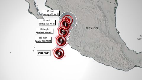
A hurricane warning is in effect for Las Islas Marias and the coast of mainland Mexico from San Blas to Mazatlán. A hurricane watch is in effect for the coast of mainland Mexico from Playa Perula to San Blas and from Mazatlán to Bahia Tempehuaya, including the city of Puerto Vallarta.
A tropical storm warning is in effect for the coast of mainland Mexico from Playa Perula to San Blas. A tropical storm watch is in…
[ad_2]
Source : cnn


